 |
Grand Isle on the Louisiana Gulf Coast
Grand Isle lies at the southern terminus of Louisiana Highway 1, a distance of some 436 miles from the highway's origination point in Shreveport.
With an official population of about 1,500 residents, Grand Isle swells to nearly 20,000 people during the summer months when camp owners and fishing rodeo attendees arrive.
The name of Grand Isle is derived the French Grande-Île, or "big island." Located directly on the Gulf of Mexico, the economy is based on tourism, the seafood industry, and oilfield related operations.
Geography of Grand Isle
Situated at the southernmost tip of Jefferson Parish, Grand Isle is a barrier island about 8 miles long and 1 mile wide, the only inhabited island on Louisiana’s Gulf coast. It is indeed a coastal community, bordered on the east by Barataria Pass, on the west by Caminada Pass, on the north by Barataria Bay, and on the south by the Gulf of Mexico.
State Highway 1 crosses a bridge from the mainland onto the island on the western side, and ends to the eastern side of the island near the state park. Highway 1 provides the only access onto the island.
 |
Grand Isle has a central ridge, elevated several feet above sea level, known as a "chenier", derived from the French for "oak ridge."
Unlike many other barrier islands in the Gulf, the chenier on Grand Isle allowed for the growth of extensive oak groves whose roots provided a livable land. Indians such as the Chitimachas and the Ouachas have lived in the area for 2,000-6,000 years and visited the island to hunt and fish.
Nearby Grande Terre was a base for the famous pirate, Jean Lafitte.
The Town ... and the Island
The island is also the town of Grand Isle, a community managed by a Town Council and Mayor. There is a Coast Guard station on the east end of the island. It also has a 100 acre beach state park, schools, a number of churches, a library, and police and fire departments.
 The Brown Pelican, The Brown Pelican,the official Louisiana State Bird, seen at Grand Isle |
Along the beach and throughout the island are a large number of private "camps" occupied during holidays and summer by owners and vacation renters. The island’s basic economy revolves around sport fishing, commercial fishing and recreational use of the beaches. It also supports several large oil and gas companies.
The island receives about 300,000 visitors a year. This influx of tourists supports many small businesses such as motels, marinas, charter boats, restaurants, grocery stores, gas stations, and businesses for clothing, supplies, bait, tackle, and recreational gear. Grand Isle hosts a number of fishing rodeos during the spring, summer, and fall, and during these times the population of the island can grow to over 20,000.
In the 19th century, Grand Isle was the location of several resorts, and was considered the summer playground of wealthy New Orleans residents. Today, it remains a popular destination for recreational and commercial fishermen who take advantage of the wide variety of fish, shrimp, crabs and oysters in the Gulf of Mexico.
Nearby South Louisiana Towns and Cities
Area communities include Port Fourchon, Leeville, Golden Meadow, Larose, Cutoff, Galliano, Chauvin, Cocodrie, Labadieville, Raceland, Morgan City, Thibodaux, and Houma.
Grand Isle Area Attractions
 The Department of Wildlife & Fisheries' Marine Lab at Grand Isle, Louisiana The Department of Wildlife & Fisheries' Marine Lab at Grand Isle, Louisiana |
Ranked as one of the top ten fishing destinations in the world, Grand Isle offers sandy beaches, crabbing, boating, swimming, surfing, bird watching, a lighted fishing pier and lots of fresh seafood, including fish, shrimp and oysters. Grand Isle has about ten miles of public beach that is maintained by the town.
The "Old Fishin' Bridge" is a public fishing bridge that is a great spot for catching trout, redfish, croaker and for crabbing.
The Lafourche/Terrebonne Scenic Byway follows historic LA 1, US 90 and LA 24. It links the historic Cajun cultural areas of Houma and Thibodaux, with their sugar cane and fishing industries. Historic LA 1 leads visitors down through numerous fishing communities to Grand Isle .
Wisner Wildlife Management Area is located 10 miles south of Leeville. Accessible only by boat, this 21,621 acre area offers excellent fishing, crabbing, shrimping, birding and boating.
The ruins of historic Fort Livingston are located on Grand Terre Island across Barataria Pass from Grand Isle, and are visible from Grand Isle State Park.
The Grand Isle Migratory Bird Festival was first established in 1997 by several nature organizations dedicated to the preservation and restoration of the Grand Isle’s chenier habitat. Originally, the festival was held on a single day, but due to increased popularity and funding, the festival has grown into a three-day event.
The Barataria-Terrebonne National Estuary is a valuable 4.2 million-acre region between the Atchafalaya and Mississippi Rivers.
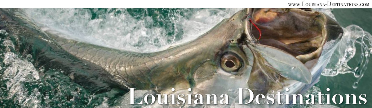
International Grand Isle Tarpon Rodeo
Off the waters of Grand Isle, fishermen can catch blue fin tuna, red snapper, redfish, flounder, yellow fin, Spanish mackerel, tarpon, barracuda, and many other species. Established in 1928, the International Grand Isle Tarpon Rodeo is the oldest fishing tournament in the United States. The big event is held during the last weekend in July that includes the Sunday.

The event has become one of the premier salt water fishing rodeos in the United States. The rodeo draws over 15,000 people annually, offering tourists the opportunity to witness the big catch, enjoy local seafood, and mingle with locals.
Swamp Tours North of the Grand Isle Area
One of the most popular things to do in Louisiana is touring the swamps!
Swamp tours are available starting at a number of area communities such as Houma, Thibodaux, Gibson, Kraemer, Patterson, Napoleonville and Theriot.
Learn more about Swamp Tours Near Houma, Morgan City & Thibodaux
Grande Isle Hotels, Motels, Vacation Rentals, and Lodging
 |
A variety of motels such as the Cajun Holiday Motel, Sandpiper Shores Motel, and the Breakers Motel are available. In addition camps, campsites, and other lodging are also available on the island, and in the State Park.
Grand Isle State Park
Grand Isle State Park, on the east end of the island, is operated by the Louisiana Office of State Parks.
It features 49 Premium Campsites, all of which are pull-through sites, all with water and electrical hookup; one is ADA compliant.
The park also features 10 Beach Tent Campsites. Canoes, paddle boats, and surf bikes can be rented onsite. The park includes a 2-1/2 mile nature trail.
Bayou Lafourche
Bayou Lafourche is a 106 mile long waterway which stretches from Donaldsonville, at the Mississippi River, to the Gulf of Mexico. From Donaldsonville, it flows through Paincourtville, Napoleonville, Labadieville, Thibodaux, Raceland, Larose, Cut Off, Galliano, Golden Meadow and finally into the Gulf near Leeville and Port Fourchon.
 |
Originally called the Chetimachas River, it flows through Ascension Parish, Assumption Parish and Lafourche Parish.
Many of the early Cajuns settled along the bayou. On the west side of the bayou is Louisiana Highway 1, and on the east bank is LA 308.
The name Lafourche is from the French word for "fork", and comes from the fact that the bayou historically carried a large amount of water from the Mississippi River. Naturally a Mississippi River outlet, Bayou Lafourche was dammed at Donaldsonville in 1905.
The dam cut off nourishment and replenishment of a huge wetland area of south Louisiana, and the bayou was gradually transformed into a stagnant ditch. Today, design efforts are underway to resume part of the flow from the Mississippi River to bring life back to the bayou.
History of Grand Isle
Early Settlers and Settlements on Grand Isle
 |
Prior to European settlement, Grand Isle was frequented by the Chitimacha, one of the Houma Indian tribes. From 1781 to 1787 four royal land grants were given to families eager to develop Grand Isle. Residents on the island raised crops, cattle, horses, and fished and hunted. Crops such as sugar cane, cotton and cucumbers were grown here. And the island provided a wealth of seafood for settlers, including shrimp, oysters, a wide variety of fish, and turtles.
The Post Civil War Era at Grand Isle
After the Civil War, the island became a popular summertime resort. Until construction of a highway to Grand Isle in the 1930s, travel to the island was usually made by steamer via the Harvey Canal and Bayou Barataria. The powerful hurricane of 1893 leveled many of the popular hotels on the island. One of the most famous of Grand Isle's 1890 resorts was the 160 room Ocean Club, built in 1892, only to be destroyed in 1893 by the storm.
Recent Grand Isle Hurricanes
 Hurricane Rita approaching the Louisiana Gulf Coast (Photo courtesy of NASA) |
On average, Grand Isle is affected by a tropical storm or hurricane every 2.68 years (since 1877), with direct hits on average every 7.88 years. Hurricane Betsy in September 1965, and Tropical Storm Frances in 1998, both put the entire island under water.
Hurricane Katrina struck Grand Isle a significant, yet glancing blow, on August 28-29, 2005. A tidal surge of six to ten feet crossed the island from the bay side, sweeping away or drastically affecting residences, camps (particularly the lower parts of camps), and businesses. Not only were buildings damaged but boats washed into the middle of the island, and the debris field created by the tidal surge was enormous. Recovery was slow and painful.
Shortly afterward, in September of 2005, Hurricane Rita dealt a smaller, glancing blow that pushed one to three feet of tidal surge from the Gulf of Mexico across the island. The end result was more damage and more debris.
Hurricane Ida came ashore near Grand Isle and Port Fourchon, Louisiana, at mid-day on August 29, 2021, as a high-end Category 4 storm with winds of 150 mph and a pressure of 929mb.
")
Hurricane Ida at landfall (August 29, 2021) |
Ida became the second most intense hurricane on record (as of 2021) to strike the State of Louisiana, behind Hurricane Katrina (2005).
It also tied for the strongest landfall in the state in terms of maximum winds with Hurricane Laura (2020) and the Last Island Hurricane (1856).
The cyclone originated from a tropical wave first monitored by the National Hurricane Center (NHC) on August
23, 2021.
Map of Grand Isle Louisiana
More Grand Isle Area Information & ResourcesGrand Isle at Visit Jefferson Parish Grand Isle at LouisianaTravel.com |
| Popular Travel Destinations and Tourist Attractions in South Louisiana |
|---|